Council Bluff

Ozark Trail - Council Bluff Lake Loop

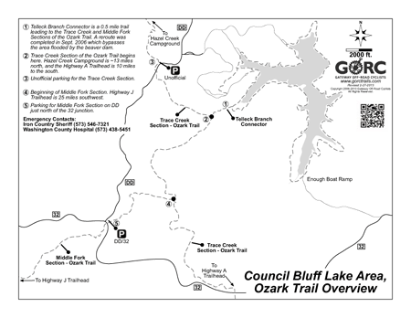
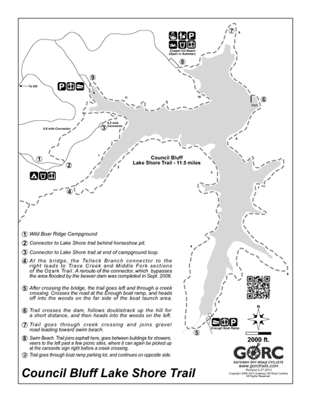
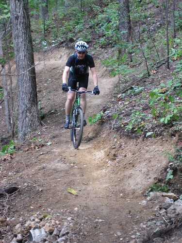
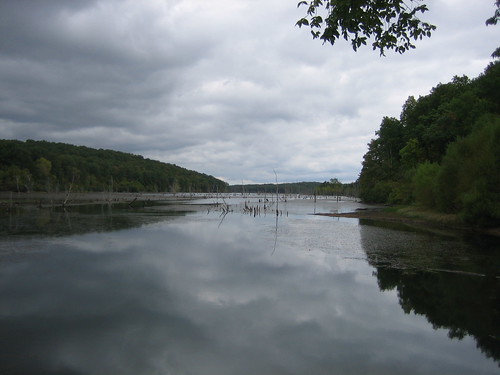
This trail was designed with mountain bikes in mind, and that becomes immediately apparent as you swoop up, down and around the little coves off the lake.  The 11.5 mile Lake Shore Trail winds around Council Bluff Lake, through a few pine and cedar groves, but never strays very far from the shore.  Most of the mileage is right next to the water.  While there is only modest elevation gain, the constant ups, downs and turns never seem to end. There are many miles of technical trail riding, but nothing too intimidating.  The trail is almost entirely singletrack with the exception of an old road bed about a mile long just before the Enough boat ramp, and a gravel road section just northeast of the swim beach.

There is also a connector along the Telleck Branch which allows you to connect with 2 major sections of the Ozark Trail: Trace Creek, and Middle Fork. From there you can get in some serious singletrack riding. 25 miles to the Highway J trailhead on the Middle Fork; 16 miles from the Telleck Connector to Hazel Creek Campground by going north on the Trace Creek section, or 8 miles south to the Highway A Trailhead. The Ozark Trail Association has just completed a reroute of the connector (Sep. 2006), which puts it up on the hillside and bypasses the flooding caused by the beaver dam. It's a great improvement over the previous trail and now the route from the campground is wide open.

Services

There are toilets, water, some concessions, coin-operated showers, and a picnic area at the swim beach which is open in the summer. Toilets and water are at the Wild Boar Ridge campground which is open in late spring and summer and offers spacious wooded campsites. There is also a toilet and a gravel parking lot at the Enough boat launch area.

Directions

From Potosi, MO go south 13 miles on Hwy P. Turn right on Hwy C, then left on Hwy DD. It's about 7 miles to the sign for Council Bluff Recreation Area.

From the South: MO 32 to MO DD. North 3 miles to Council Bluff sign. Turn right.
Trailheads are at both the boat ramp and the Wild Boar Ridge Campground. There is a $3 day use fee.

Trail Information

Trail Steward(s)

Rating

Intermediate

Length

12 miles

Type

Loop

Weather

Trail Conditions

Latest Conditions

From mawill30 on Tue, 12/26/2023 - 4:56pm - Council Bluff (Ozark Region)
Ideal dirt conditions One tree across trail at 6 mile point… easy to ride around.
From Bartman on Sat, 05/20/2023 - 3:33pm - Council Bluff (Ozark Region)
Trail in excellent condition. Low spots still pretty wet but passable. Creek at south end very full.
From soberstormtrooper on Sun, 10/09/2022 - 11:39am - Council Bluff (Ozark Region)
Trail is nearly as good as it gets but rocky, technical and punchy, several of us missed the turn towards the Enough boat ramp but it was fairly obvious when you arrived at closed gate to turn around and see where the turn was missed.
From Ephemeral_Distr... on Sun, 10/10/2021 - 2:45pm - Council Bluff (Ozark Region)
Dry and clear. Great shape. Water is off already in the campground, self-pay protocol in place. Campground closes Nov 23rd per Ranger District.
From Deserteagle99uzi on Thu, 10/22/2020 - 1:00pm - Council Bluff (Ozark Region)
Dry, clear and fast. Most leaves are down but trail was in excellent shape with only a single tree down near the campground spur just north of the OT connector.
From MTBKona22 on Sun, 08/30/2020 - 5:10pm - Council Bluff (Ozark Region)
If you didn't see on UFD Facebook page: The trail is completely tree cleared and the entire loop was hit with weed wackers this weekend. Trail is good to go.